Maps with decimal distances
key notes :
📏 What is a Map Distance?
Map distance is the distance between two points on a map.
Usually measured in centimeters (cm) or meters (m) depending on the map.
🧮 Using Decimals in Maps
Sometimes, distances are not whole numbers → we use decimal numbers.
Example: 3.5 km, 2.75 km.
Decimals make distances more accurate.
🗺️ Scale of a Map
Scale shows how map distances relate to real distances.
Example: 1 cm : 5 km → 1 cm on the map = 5 km in real life.
Formula: Real Distance=Map Distance×Scale Factor\text{Real Distance} = \text{Map Distance} \times \text{Scale Factor}Real Distance=Map Distance×Scale Factor
➕ Adding Decimal Distances
When traveling multiple routes, add decimal distances carefully.
Example: 2.5 km + 3.7 km = 6.2 km ✅
➖ Subtracting Decimal Distances
To find shorter distances between points, subtract decimals.
Example: 5.6 km − 2.4 km = 3.2 km ✅
✖️ Multiplying Decimal Distances
Sometimes, a map distance is multiplied by a scale to get real distance.
Example: Map distance = 2.4 cm, Scale = 5 km/cm → Real distance = 2.4 × 5 = 12 km
➗ Dividing Decimal Distances
Used when finding distance per unit.
Example: 15 km ÷ 3 = 5 km per route
📌 Tips for Accuracy
Always align decimal points when adding or subtracting.
Check units: cm on map vs km in real life.
Round decimals only when necessary.
🎯 Practice Makes Perfect
Measure distances on any map and convert using scale.
Use decimal operations to calculate total, remaining, or per unit distances.
💡 Fun Emoji Memory Trick:
- 📏 → measure
- 🗺️ → map
- 🧮 → decimal calculation
- ➕➖✖️➗ → add, subtract, multiply, divide distances
Learn with an example
Using the paths shown, the distance from Belmont to Allenville is 6.5 kilometers.
How far is it from Booneville to Allenville?
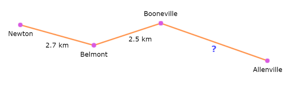
To find the total distance, add up the paths:
| Belmont to Booneville | 2.5 km |
| Booneville to Allenville | ? |
You already know the total distance is 6.5 kilometers, so solve for the missing
distance:
2.5 + ? = 6.5
? = 6.5 − 2.5
? = 4
So, the distance from Booneville to Allenville is 4 kilometers.
Using the paths shown, the distance from Hillsboro to Georgetown is 4.3 kilometers.
How far is it from Hillsboro to Milford?
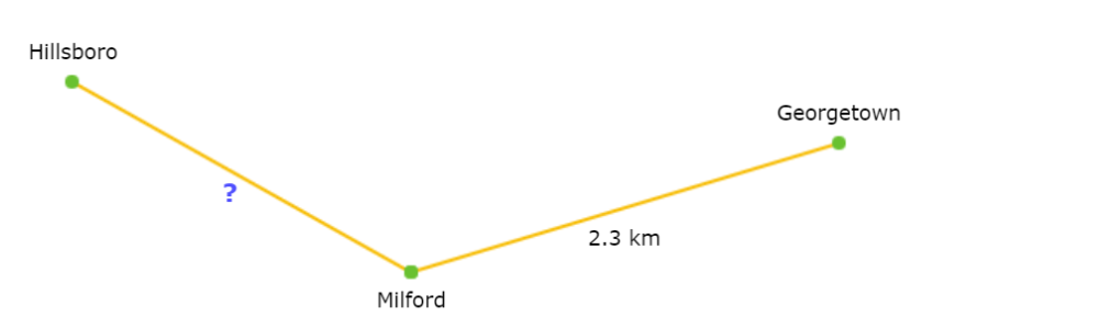
To find the total distance, add up the paths:
| Hillsboro to Milford | ? | |
| Milford to Georgetown | 2.3 km |
You already know the total distance is 4.3 kilometers, so solve for the missing
distance:
? + 2.3 = 4.3
? = 4.3 − 2.3
? = 2
So, the distance from Hillsboro to Milford is 2 kilometers.
Using the paths shown,
how far is it from Newberry to Kensington?

_____ km
To find the total distance, add up the paths:
| Newberry to Newton | 10 km | |
| Newton to Lexington | 4.1 km | |
| Lexington to Kensington | 7.8 km |
10 + 4.1 + 7.8 = 21.9
So, the total distance from Newberry to Kensington is 21.9 kilometers.
Let’s practice!